
Rose Island topographic map
Interactive map
Click on the map to display elevation.
About this map
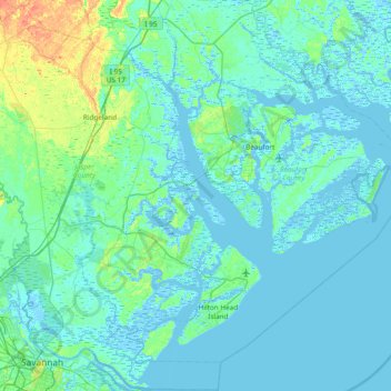
Name: Rose Island topographic map, elevation, terrain.
Average elevation: 5 m
Minimum elevation: -6 m
Maximum elevation: 41 m
Other topographic maps
Click on a map to view its topography, its elevation and its terrain.
Parris Island
United States > South Carolina > Beaufort County > Port Royal
Parris Island, Port Royal, Beaufort County, South Carolina, 29905, United States
Average elevation: 3 m
Port Royal Landing
United States > South Carolina > Beaufort County > Port Royal > Port Royal Landing
Port Royal Landing, Port Royal, Beaufort County, South Carolina, 29935, United States
Average elevation: 5 m
Green Pond
United States > South Carolina > Beaufort County > Port Royal > Green Pond
Green Pond, Port Royal, Beaufort County, South Carolina, United States
Average elevation: 4 m