
Sint Eustatius topographic map
Interactive map
Click on the map to display elevation.
About this map
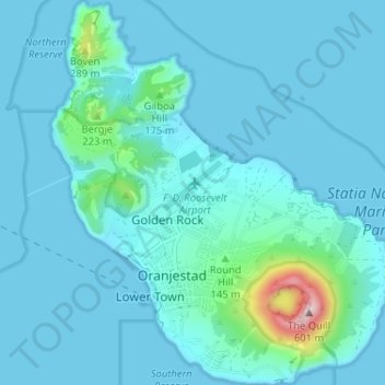
Name: Sint Eustatius topographic map, elevation, terrain.
Location: Sint Eustatius, Caribisch Nederland, Nederland (17.46458 -63.00314 17.52605 -62.94591)
Average elevation: 48 m
Minimum elevation: 0 m
Maximum elevation: 559 m
Other topographic maps
Click on a map to view its topography, its elevation and its terrain.
Sint Eustatius
Nederland > Caribisch Nederland
Sint Eustatius, Caribisch Nederland, Nederland
Average elevation: 8 m
Washington-Slagbaai National Park
Nederland > Caribisch Nederland > Bonaire
Washington-Slagbaai National Park, Bonaire, Caribisch Nederland, Nederland
Average elevation: 45 m
The Quill
Nederland > Caribisch Nederland
The Quill, Sint Eustatius, Caribisch Nederland, Nederland
Average elevation: 143 m