
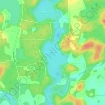
Lac Bonnécal topographic map
Interactive map
Click on the map to display elevation.
About this map
Name: Lac Bonnécal topographic map, elevation, terrain.
Average elevation: 206 m
Minimum elevation: 186 m
Maximum elevation: 237 m
Other topographic maps
Click on a map to view its topography, its elevation and its terrain.
Rivière du Lièvre
Canada > Québec > Antoine-Labelle > Notre-Dame-du-Laus
Rivière du Lièvre, Notre-Dame-du-Laus, Antoine-Labelle, Laurentides, Québec, Canada
Average elevation: 273 m
Lac Vert
Canada > Québec > Antoine-Labelle > Notre-Dame-du-Laus
Lac Vert, Notre-Dame-du-Laus, Antoine-Labelle, Laurentides, Québec, Canada
Average elevation: 228 m
Lac Saint-Denis
Canada > Québec > Antoine-Labelle > Notre-Dame-du-Laus
Lac Saint-Denis, Notre-Dame-du-Laus, Antoine-Labelle, Laurentides, Québec, Canada
Average elevation: 279 m
Lac Adrien
Canada > Québec > Antoine-Labelle > Notre-Dame-du-Laus
Lac Adrien, Notre-Dame-du-Laus, Antoine-Labelle, Laurentides, Québec, Canada
Average elevation: 243 m
Lac du Poisson Blanc
Canada > Québec > Antoine-Labelle > Notre-Dame-du-Laus
Lac du Poisson Blanc, Notre-Dame-du-Laus, Antoine-Labelle, Laurentides, Québec, J0X 2M0, Canada
Average elevation: 258 m
Montagne du Diable
Canada > Québec > Antoine-Labelle > Notre-Dame-du-Laus
Montagne du Diable, Notre-Dame-du-Laus, Antoine-Labelle, Laurentides, Québec, Canada
Average elevation: 336 m
Rivière du Sourd
Canada > Québec > Antoine-Labelle > Notre-Dame-du-Laus
Rivière du Sourd, Notre-Dame-du-Laus, Antoine-Labelle, Laurentides, Québec, Canada
Average elevation: 296 m
Lac Jaune
Canada > Québec > Antoine-Labelle > Notre-Dame-du-Laus
Lac Jaune, Notre-Dame-du-Laus, Antoine-Labelle, Laurentides, Québec, Canada
Average elevation: 367 m
Lac du Corbeau
Canada > Québec > Antoine-Labelle > Notre-Dame-du-Laus
Lac du Corbeau, Notre-Dame-du-Laus, Antoine-Labelle, Laurentides, Québec, Canada
Average elevation: 243 m
Lac Malpic
Canada > Québec > Antoine-Labelle > Notre-Dame-du-Laus
Lac Malpic, Notre-Dame-du-Laus, Antoine-Labelle, Laurentides, Québec, Canada
Average elevation: 316 m