
Thank you for supporting this site ❤️
Make a donation
Make a donation
Gear up for your next adventure:
As an Amazon Associate, this site earns from qualifying purchases at no extra cost to you.
Diepenlinchen topographic map
Click on the map to display elevation.
Thank you for supporting this site ❤️
Make a donation
Make a donation
Gear up for your next adventure:
As an Amazon Associate, this site earns from qualifying purchases at no extra cost to you.
Diepenlinchen
Diepenlinchen ist ein Ortsteil des Stolberger Stadtteils Mausbach in der Städteregion Aachen. Der Ort liegt auf 295,9 m ü. NHN Höhe.
Thank you for supporting this site ❤️
Make a donation
Make a donation
Gear up for your next adventure:
As an Amazon Associate, this site earns from qualifying purchases at no extra cost to you.
About this map
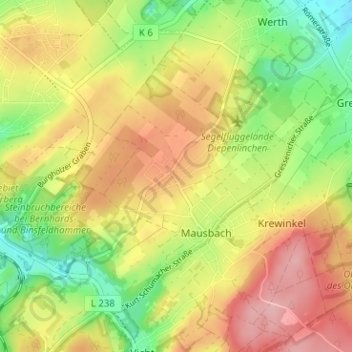
Name: Diepenlinchen topographic map, elevation, terrain.
Average elevation: 263 m
Minimum elevation: 194 m
Maximum elevation: 329 m
Thank you for supporting this site ❤️
Make a donation
Make a donation
Gear up for your next adventure:
As an Amazon Associate, this site earns from qualifying purchases at no extra cost to you.