
Make a donation
Gear up for your next adventure:
As an Amazon Associate, this site earns from qualifying purchases at no extra cost to you.
Borgloh topographic map
Click on the map to display elevation.
Make a donation
Gear up for your next adventure:
As an Amazon Associate, this site earns from qualifying purchases at no extra cost to you.
About this map
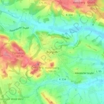
Name: Borgloh topographic map, elevation, terrain.
Average elevation: 127 m
Minimum elevation: 86 m
Maximum elevation: 201 m
Make a donation
Gear up for your next adventure:
As an Amazon Associate, this site earns from qualifying purchases at no extra cost to you.
Other topographic maps
Click on a map to view its topography, its elevation and its terrain.
Make a donation
Gear up for your next adventure:
As an Amazon Associate, this site earns from qualifying purchases at no extra cost to you.
Bad Essen
Germany > Lower Saxony > Landkreis Osnabrück
The town of Bad Essen is on the North German Plains, because of the transition of the low mountain range to the plains. The Wiehengebirge Range covers approximately the southern third of the town and reaches an elevation of 211m above sea level. The highest point of the Wiehengebirge Range is on the black…
Average elevation: 79 m
Georgsmarienhütte
Germany > Lower Saxony > Landkreis Osnabrück > Georgsmarienhütte
Average elevation: 133 m
Make a donation
Gear up for your next adventure:
As an Amazon Associate, this site earns from qualifying purchases at no extra cost to you.