
Make a donation
Gear up for your next adventure:
As an Amazon Associate, this site earns from qualifying purchases at no extra cost to you.
Sable Island topographic map
Click on the map to display elevation.
Make a donation
Gear up for your next adventure:
As an Amazon Associate, this site earns from qualifying purchases at no extra cost to you.
Sable Island
Sable Island is a narrow, crescent-shaped sandbar with a surface area estimated around 34 km2 (13 sq mi). Despite being approximately 43.15 km (26.81 mi) long, it is only 1.21 km (0.75 mi) across at its widest point. The maximum elevation is about 30 m (98 ft). The long crescent-shaped island rises gently from the shallows of the continental shelf approximately 285 km (177 mi) east of Halifax, Nova Scotia. Its location, in tandem with the area's frequent fog and sudden strong storms (such as hurricanes and nor'easters), have resulted in over 350 recorded shipwrecks. It is often referred to as the Graveyard of the Atlantic, as it sits astride the great circle route from North America's east coast to Europe. The nearest landfall is 160 kilometres (99 mi) to the northwest near Canso, Nova Scotia.
Make a donation
Gear up for your next adventure:
As an Amazon Associate, this site earns from qualifying purchases at no extra cost to you.
About this map
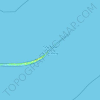
Name: Sable Island topographic map, elevation, terrain.
Average elevation: 0 m
Minimum elevation: -5 m
Maximum elevation: 19 m
Make a donation
Gear up for your next adventure:
As an Amazon Associate, this site earns from qualifying purchases at no extra cost to you.