
Make a donation
Gear up for your next adventure:
As an Amazon Associate, this site earns from qualifying purchases at no extra cost to you.
Pforzheim topographic map
Click on the map to display elevation.
Make a donation
Gear up for your next adventure:
As an Amazon Associate, this site earns from qualifying purchases at no extra cost to you.
About this map
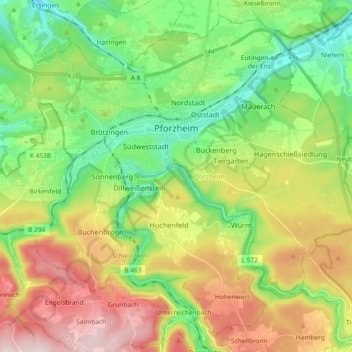
Name: Pforzheim topographic map, elevation, terrain.
Location: Pforzheim, Neulingen, Baden-Württemberg, Germany (48.81901 8.62488 48.92970 8.80874)
Average elevation: 389 m
Minimum elevation: 212 m
Maximum elevation: 671 m
Make a donation
Gear up for your next adventure:
As an Amazon Associate, this site earns from qualifying purchases at no extra cost to you.
Other topographic maps
Click on a map to view its topography, its elevation and its terrain.
Lauterbad
Germany > Baden-Württemberg > Landkreis Freudenstadt > Freudenstadt > Dietersweiler
Average elevation: 702 m
Make a donation
Gear up for your next adventure:
As an Amazon Associate, this site earns from qualifying purchases at no extra cost to you.
Lützenhardt
Germany > Baden-Württemberg > Landkreis Freudenstadt > Waldachtal
Average elevation: 615 m
Hollerbach
Germany > Baden-Württemberg > Neckar-Odenwald-Kreis > Buchen (Odenwald)
Average elevation: 395 m
Make a donation
Gear up for your next adventure:
As an Amazon Associate, this site earns from qualifying purchases at no extra cost to you.