
Cours topographic map
Interactive map
Click on the map to display elevation.
About this map
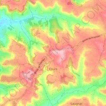
Name: Cours topographic map, elevation, terrain.
Average elevation: 164 m
Minimum elevation: 79 m
Maximum elevation: 229 m
Other topographic maps
Click on a map to view its topography, its elevation and its terrain.
Saint-Maurin
France > Nouvelle-Aquitaine > Lot-et-Garonne
Saint-Maurin, Agen, Lot-et-Garonne, Nouvelle-Aquitaine, Metropolitan France, 47270, France
Average elevation: 149 m