Geolocate

Rabat topographic map

Click on the map to display elevation.

About this map

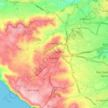
Name: Rabat topographic map, elevation, terrain.

Location: Rabat, Northern Region, Malta (35.86148 14.32814 35.90767 14.41699)

Average elevation: 135 m

Minimum elevation: 0 m

Maximum elevation: 252 m

Gear up for your next adventure:

🧺Quick-Dry Hiking Towels - Space-saving towels for wild swimming or camping
🔌Fast Car Chargers - Recharge GPS and phones between trailheads
🩻Outdoor Health Essentials - Necessary health items for hikes
🧺Waterproof Picnic Blankets - Dry seating for breaks on damp grass
🔭Portable Monoculars - One-handed optics for quick route checking

As an Amazon Associate, this site earns from qualifying purchases at no extra cost to you.