
Make a donation
Gear up for your next adventure:
As an Amazon Associate, this site earns from qualifying purchases at no extra cost to you.
Eichenau topographic map
Click on the map to display elevation.
Make a donation
Gear up for your next adventure:
As an Amazon Associate, this site earns from qualifying purchases at no extra cost to you.
Eichenau
Die Spannungen mit der Muttergemeinde Alling erreichten ihren Höhepunkt 1925, als die mehrheitlich Eichenauer Gemeinderäte die Verlegung der Gemeindeverwaltung nach Eichenau beschlossen.
Make a donation
Gear up for your next adventure:
As an Amazon Associate, this site earns from qualifying purchases at no extra cost to you.
About this map
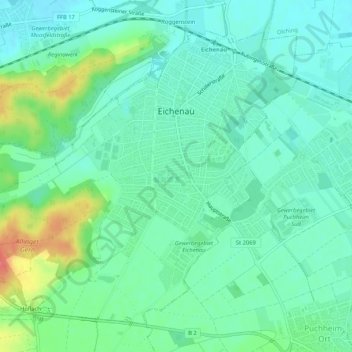
Name: Eichenau topographic map, elevation, terrain.
Average elevation: 530 m
Minimum elevation: 510 m
Maximum elevation: 585 m
Make a donation
Gear up for your next adventure:
As an Amazon Associate, this site earns from qualifying purchases at no extra cost to you.
Other topographic maps
Click on a map to view its topography, its elevation and its terrain.
Pleitmannswang
Deutschland > Bayern > Landkreis Fürstenfeldbruck > Türkenfeld
Average elevation: 568 m
Make a donation
Gear up for your next adventure:
As an Amazon Associate, this site earns from qualifying purchases at no extra cost to you.
Weiherhaus
Deutschland > Bayern > Landkreis Fürstenfeldbruck > Fürstenfeldbruck > Gelbenholzen
Average elevation: 543 m
Make a donation
Gear up for your next adventure:
As an Amazon Associate, this site earns from qualifying purchases at no extra cost to you.
Make a donation
Gear up for your next adventure:
As an Amazon Associate, this site earns from qualifying purchases at no extra cost to you.