
Maducang Island topographic map
Interactive map
Click on the map to display elevation.
About this map
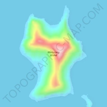
Name: Maducang Island topographic map, elevation, terrain.
Location: Maducang Island, Palawan, Mimaropa, Philippines (10.69318 120.25317 10.71765 120.27042)
Average elevation: 31 m
Minimum elevation: -1 m
Maximum elevation: 266 m
Other topographic maps
Click on a map to view its topography, its elevation and its terrain.
Long Beach
Philippines > Palawan > Roxas
Long Beach, Roxas, Palawan, Mimaropa, Philippines
Average elevation: 17 m
Balabac Island
Balabac Island, Palawan, Mimaropa, Philippines
Average elevation: 20 m
Busuanga Island
Busuanga Island, Coron, Palawan, Mimaropa, 5316, Philippines
Average elevation: 33 m