
Shipol topographic map
Interactive map
Click on the map to display elevation.
About this map
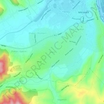
Name: Shipol topographic map, elevation, terrain.
Location: Shipol, Mitrovica Municipality, 38220, Kosovo (42.84376 20.82922 42.88376 20.86922)
Average elevation: 554 m
Minimum elevation: 502 m
Maximum elevation: 707 m
Other topographic maps
Click on a map to view its topography, its elevation and its terrain.
Fushë Kosovë
Kosovo Polje is a municipality that lies in the center of the Kosovo Plain, with an area of 84 km2 (32 sq mi) and an altitude of 540 m (1,772 ft) above sea level. The city is situated between Pristina in the east, Obiliq in the north, Graçanica in the south and Drenas in the west. It consists of 16…
Average elevation: 551 m
Pristina
Kosovo > Municipality of Pristina
By the early Iron Age, the distinctly Dardanian local variant of the Illyrian Glasinac-Mati culture appears in Kosovo with a particular spread in hilltop settlements. In the area of Pristina, a hilltop settlement appears since the 8th century BCE at an elevation of 685 metres near the village Teneshdoll,…
Average elevation: 650 m