
Missy topographic map
Interactive map
Click on the map to display elevation.
About this map
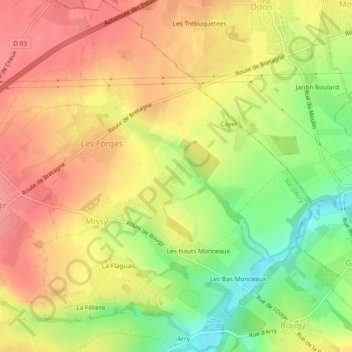
Name: Missy topographic map, elevation, terrain.
Average elevation: 102 m
Minimum elevation: 48 m
Maximum elevation: 134 m
Other topographic maps
Click on a map to view its topography, its elevation and its terrain.
Ragny
France > Normandie > Calvados > Val d'Arry > Tournay-sur-Odon
Ragny, Tournay-sur-Odon, Val d'Arry, Vire, Calvados, Normandie, France métropolitaine, 14310, France
Average elevation: 111 m
Tournay-sur-Odon
France > Normandie > Calvados > Val d'Arry
Tournay-sur-Odon, Val d'Arry, Vire, Calvados, Normandie, France métropolitaine, 14310, France
Average elevation: 121 m
La Cour d'Arry
France > Normandie > Calvados > Val d'Arry > Le Locheur > La Cour d'Arry
La Cour d'Arry, Le Locheur, Val d'Arry, Vire, Calvados, Normandie, France métropolitaine, 14210, France
Average elevation: 94 m