Geolocate

Keystone topographic map

Click on the map to display elevation.

About this map

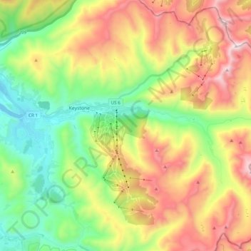
Name: Keystone topographic map, elevation, terrain.

Location: Keystone, Summit County, Colorado, 80435, United States (39.52173 -106.00609 39.67140 -105.86022)

Average elevation: 3,300 m

Minimum elevation: 2,749 m

Maximum elevation: 4,089 m

Gear up for your next adventure:

🪶Ultralight Tents - Lightweight shelters for hikers
🖊️All-Weather Pens - Pressurized ink cartridges that write upside down and in wet
🦯Lightweight Trekking Poles - Reduce knee strain on steep Wicklow or Kerry slopes
📡Satellite Messengers - Emergency messaging when off‑grid
📦Outdoor Storage Bags - Keep gear organized and dry

As an Amazon Associate, this site earns from qualifying purchases at no extra cost to you.