
Make a donation
Gear up for your next adventure:
As an Amazon Associate, this site earns from qualifying purchases at no extra cost to you.
Douglas topographic map
Click on the map to display elevation.
Make a donation
Gear up for your next adventure:
As an Amazon Associate, this site earns from qualifying purchases at no extra cost to you.
Douglas
The principal elevations are Bald Hill, 711 feet (217 m), Wallum Pond Hill, 778 feet (237 m), Mount Ashworth, 713 feet (218 m), and Mount Daniel, 735 feet (224 m). There are numerous ponds in Douglas: Wallum Pond in the southwestern section, covering approximately 150 acres (61 ha); Badluck Pond in the western part of town, covering about 110 acres (45 ha); the largest pond is Whitin Reservoir, also in the western part of town, covering about 400 acres (160 ha); and Manchaug Pond in the northern part, about 93 acres (38 ha).
Make a donation
Gear up for your next adventure:
As an Amazon Associate, this site earns from qualifying purchases at no extra cost to you.
About this map
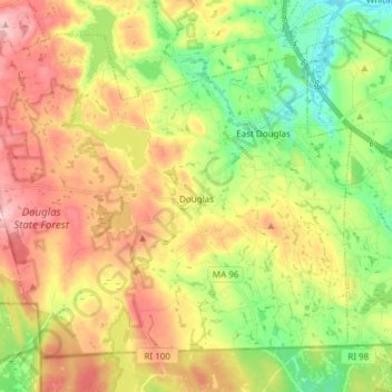
Name: Douglas topographic map, elevation, terrain.
Average elevation: 173 m
Minimum elevation: 87 m
Maximum elevation: 273 m
Make a donation
Gear up for your next adventure:
As an Amazon Associate, this site earns from qualifying purchases at no extra cost to you.
Other topographic maps
Click on a map to view its topography, its elevation and its terrain.
Make a donation
Gear up for your next adventure:
As an Amazon Associate, this site earns from qualifying purchases at no extra cost to you.
Wachusett Station
United States > Massachusetts > Worcester County > Fitchburg
Average elevation: 229 m
Central (Stanley) Woolen Mill District Park
United States > Massachusetts > Worcester County > Uxbridge
Average elevation: 80 m
Make a donation
Gear up for your next adventure:
As an Amazon Associate, this site earns from qualifying purchases at no extra cost to you.
Crow Hill Ledges
United States > Massachusetts > Worcester County > Westminster
Average elevation: 293 m
Olde English Village
United States > Massachusetts > Worcester County > Gardner
Average elevation: 308 m
Make a donation
Gear up for your next adventure:
As an Amazon Associate, this site earns from qualifying purchases at no extra cost to you.
Vernon Hill
United States > Massachusetts > Worcester County > Worcester > Quinsigamond Village
Average elevation: 162 m
Make a donation
Gear up for your next adventure:
As an Amazon Associate, this site earns from qualifying purchases at no extra cost to you.
Tatnuck
United States > Massachusetts > Worcester County > Worcester > Tatnuck Square
Average elevation: 221 m
Make a donation
Gear up for your next adventure:
As an Amazon Associate, this site earns from qualifying purchases at no extra cost to you.
Institute Park
United States > Massachusetts > Worcester County > Worcester > Belmont Hill
Average elevation: 170 m
Make a donation
Gear up for your next adventure:
As an Amazon Associate, this site earns from qualifying purchases at no extra cost to you.
Hadwen Park
United States > Massachusetts > Worcester County > Worcester > Heard Street
Average elevation: 166 m
Make a donation
Gear up for your next adventure:
As an Amazon Associate, this site earns from qualifying purchases at no extra cost to you.
Thompsons Pond Dam
United States > Massachusetts > Worcester County > Spencer
Average elevation: 278 m
Make a donation
Gear up for your next adventure:
As an Amazon Associate, this site earns from qualifying purchases at no extra cost to you.
Make a donation
Gear up for your next adventure:
As an Amazon Associate, this site earns from qualifying purchases at no extra cost to you.
Northbridge Center
United States > Massachusetts > Worcester County > Northbridge
Average elevation: 124 m
Make a donation
Gear up for your next adventure:
As an Amazon Associate, this site earns from qualifying purchases at no extra cost to you.
Blackburn Village
United States > Massachusetts > Worcester County > Ashburnham
Average elevation: 326 m
Phillipston Four Corners
United States > Massachusetts > Worcester County > Phillipston
Average elevation: 335 m
Make a donation
Gear up for your next adventure:
As an Amazon Associate, this site earns from qualifying purchases at no extra cost to you.
Make a donation
Gear up for your next adventure:
As an Amazon Associate, this site earns from qualifying purchases at no extra cost to you.
Make a donation
Gear up for your next adventure:
As an Amazon Associate, this site earns from qualifying purchases at no extra cost to you.
Make a donation
Gear up for your next adventure:
As an Amazon Associate, this site earns from qualifying purchases at no extra cost to you.
South Charlton Reservoir
United States > Massachusetts > Worcester County > Charlton > South Charlton
Average elevation: 203 m
Make a donation
Gear up for your next adventure:
As an Amazon Associate, this site earns from qualifying purchases at no extra cost to you.
West Upton
United States > Massachusetts > Worcester County > Upton > West Upton
Average elevation: 111 m
Make a donation
Gear up for your next adventure:
As an Amazon Associate, this site earns from qualifying purchases at no extra cost to you.
Jefferson
United States > Massachusetts > Worcester County > Holden > Jefferson
Average elevation: 248 m
Hadwen Arboretum
United States > Massachusetts > Worcester County > Worcester > Main South
Average elevation: 165 m
Martha Templeton Rock
United States > Massachusetts > Worcester County > Southborough
Average elevation: 95 m
Make a donation
Gear up for your next adventure:
As an Amazon Associate, this site earns from qualifying purchases at no extra cost to you.
Make a donation
Gear up for your next adventure:
As an Amazon Associate, this site earns from qualifying purchases at no extra cost to you.
Turkey Hill Shores
United States > Massachusetts > Worcester County > Rutland
Average elevation: 312 m