
Make a donation
Gear up for your next adventure:
As an Amazon Associate, this site earns from qualifying purchases at no extra cost to you.
Idlib District topographic map
Click on the map to display elevation.
Make a donation
Gear up for your next adventure:
As an Amazon Associate, this site earns from qualifying purchases at no extra cost to you.
About this map
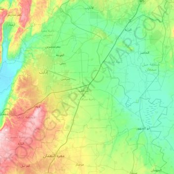
Name: Idlib District topographic map, elevation, terrain.
Location: Idlib District, Idlib Governorate, Syria (35.60473 36.42950 36.14367 37.14396)
Average elevation: 392 m
Minimum elevation: 215 m
Maximum elevation: 919 m
Make a donation
Gear up for your next adventure:
As an Amazon Associate, this site earns from qualifying purchases at no extra cost to you.
Other topographic maps
Click on a map to view its topography, its elevation and its terrain.
Make a donation
Gear up for your next adventure:
As an Amazon Associate, this site earns from qualifying purchases at no extra cost to you.
Make a donation
Gear up for your next adventure:
As an Amazon Associate, this site earns from qualifying purchases at no extra cost to you.
Harim
Harem or Harim (Arabic: حَارِم, romanized: Ḥārim, also Ḥāram) is a Syrian city within the Idlib Governorate. It has an altitude of 160 meters and a population of 21,934. Harem is situated on the border with Turkey, 55 km west of Aleppo.
Average elevation: 222 m