
Make a donation
Gear up for your next adventure:
As an Amazon Associate, this site earns from qualifying purchases at no extra cost to you.
Deux-Nants topographic map
Click on the map to display elevation.
Make a donation
Gear up for your next adventure:
As an Amazon Associate, this site earns from qualifying purchases at no extra cost to you.
About this map
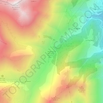
Name: Deux-Nants topographic map, elevation, terrain.
Average elevation: 1,729 m
Minimum elevation: 992 m
Maximum elevation: 2,530 m
Make a donation
Gear up for your next adventure:
As an Amazon Associate, this site earns from qualifying purchases at no extra cost to you.
Other topographic maps
Click on a map to view its topography, its elevation and its terrain.
Saint-Jean-de-Belleville
France > Auvergne-Rhône-Alpes > Savoie > Les Belleville
Le chef-lieu de la commune se trouve à 1 110 m d'altitude, à 12 km au sud de Moûtiers. L'accès en provenance de cette dernière se fait par la route départementale D117.
Average elevation: 1,806 m