
Make a donation
Gear up for your next adventure:
As an Amazon Associate, this site earns from qualifying purchases at no extra cost to you.
Don Carlos topographic map
Click on the map to display elevation.
Make a donation
Gear up for your next adventure:
As an Amazon Associate, this site earns from qualifying purchases at no extra cost to you.
Don Carlos
The terrain of the municipality of Don Carlos is generally flat except the mountain range on the eastern part of the municipality. The highest elevation is 700 metres (2,300 ft) above sea level and the lowest elevation is 300 metres (980 ft) below sea level.
Make a donation
Gear up for your next adventure:
As an Amazon Associate, this site earns from qualifying purchases at no extra cost to you.
About this map
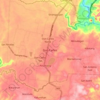
Name: Don Carlos topographic map, elevation, terrain.
Location: Don Carlos, Bukidnon, Northern Mindanao, 088, Philippines (7.64036 124.95907 7.72036 125.03907)
Average elevation: 299 m
Minimum elevation: 161 m
Maximum elevation: 355 m
Make a donation
Gear up for your next adventure:
As an Amazon Associate, this site earns from qualifying purchases at no extra cost to you.
Other topographic maps
Click on a map to view its topography, its elevation and its terrain.