
Thank you for supporting this site ❤️
Make a donation
Make a donation
Gear up for your next adventure:
As an Amazon Associate, this site earns from qualifying purchases at no extra cost to you.
Rechnitz topographic map
Click on the map to display elevation.
Thank you for supporting this site ❤️
Make a donation
Make a donation
Gear up for your next adventure:
As an Amazon Associate, this site earns from qualifying purchases at no extra cost to you.
About this map
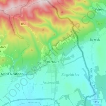
Name: Rechnitz topographic map, elevation, terrain.
Location: Rechnitz, Bezirk Oberwart, Burgenland, 7471, Austria (47.27086 16.38423 47.35292 16.48942)
Average elevation: 423 m
Minimum elevation: 258 m
Maximum elevation: 874 m
Thank you for supporting this site ❤️
Make a donation
Make a donation
Gear up for your next adventure:
As an Amazon Associate, this site earns from qualifying purchases at no extra cost to you.