
Prince Edward Island topographic map
Interactive map
Click on the map to display elevation.
About this map
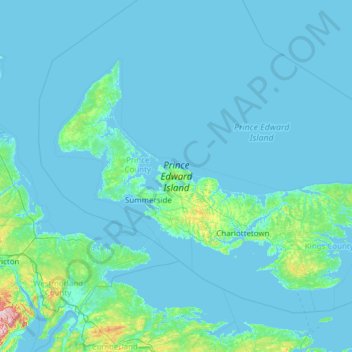
Name: Prince Edward Island topographic map, elevation, terrain.
Location: Prince Edward Island, Canada (45.94829 -64.41380 47.05897 -61.97077)
Average elevation: 13 m
Minimum elevation: -3 m
Maximum elevation: 393 m
Other topographic maps
Click on a map to view its topography, its elevation and its terrain.
Hermanville
Canada > Prince Edward Island > Kings County
Hermanville, Kings County, Prince Edward Island, Canada
Average elevation: 23 m
Cavendish Beach Trail
Canada > Prince Edward Island > Resort Municipality of Stanley Bridge, Hope River, Bayview, Cavendish and North Rustico > Cavendish
Cavendish Beach Trail, Cavendish, Resort Municipality of Stanley Bridge, Hope River, Bayview, Cavendish and North Rustico, Queens County, Prince Edward Island, C0A 1N0, Canada
Average elevation: 18 m
Greenmount
Canada > Prince Edward Island > Prince County > Greenmount
Greenmount, Rural Municipality of Greenmount-Montrose, Prince County, Prince Edward Island, Canada
Average elevation: 19 m
Church Road
Church Road, Lot 40, Kings County, Prince Edward Island, Canada
Average elevation: 34 m