
County Durham topographic map
Interactive map
Click on the map to display elevation.
About this map
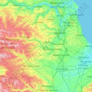
Name: County Durham topographic map, elevation, terrain.
Location: County Durham, North East England, England, United Kingdom (54.45148 -2.35574 54.91869 -1.23969)
Average elevation: 195 m
Minimum elevation: -2 m
Maximum elevation: 784 m
Other topographic maps
Click on a map to view its topography, its elevation and its terrain.
Benfieldside
United Kingdom > England > County Durham > Consett
Benfieldside, Consett, County Durham, North East, England, DH8 0RW, United Kingdom
Average elevation: 179 m
Templetown
United Kingdom > England > County Durham > Templetown
Templetown, County Durham, North East England, England, DH8 7BL, United Kingdom
Average elevation: 217 m
Carrs Hill
United Kingdom > England > County Durham
Carrs Hill, County Durham, North East England, England, DL12 0RP, United Kingdom
Average elevation: 506 m