
Thank you for supporting this site ❤️
Make a donation
Make a donation
Gear up for your next adventure:
As an Amazon Associate, this site earns from qualifying purchases at no extra cost to you.
Wasserkuppe topographic map
Click on the map to display elevation.
Thank you for supporting this site ❤️
Make a donation
Make a donation
Gear up for your next adventure:
As an Amazon Associate, this site earns from qualifying purchases at no extra cost to you.
Wasserkuppe
Die Wasserkuppe ist mit 950 m ü. NHN Höhe der höchste Berg der Rhön und zugleich die höchste Erhebung in Hessen. Sie liegt im Landkreis Fulda mit Gipfellage im Gebiet von Gersfeld.
Thank you for supporting this site ❤️
Make a donation
Make a donation
Gear up for your next adventure:
As an Amazon Associate, this site earns from qualifying purchases at no extra cost to you.
About this map
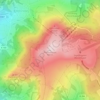
Name: Wasserkuppe topographic map, elevation, terrain.
Average elevation: 796 m
Minimum elevation: 608 m
Maximum elevation: 953 m
Thank you for supporting this site ❤️
Make a donation
Make a donation
Gear up for your next adventure:
As an Amazon Associate, this site earns from qualifying purchases at no extra cost to you.