
Make a donation
Gear up for your next adventure:
As an Amazon Associate, this site earns from qualifying purchases at no extra cost to you.
Jalun Lake topographic map
Click on the map to display elevation.
Make a donation
Gear up for your next adventure:
As an Amazon Associate, this site earns from qualifying purchases at no extra cost to you.
About this map
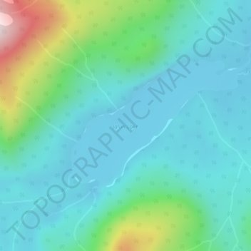
Name: Jalun Lake topographic map, elevation, terrain.
Average elevation: 207 m
Minimum elevation: 104 m
Maximum elevation: 607 m
Make a donation
Gear up for your next adventure:
As an Amazon Associate, this site earns from qualifying purchases at no extra cost to you.
Other topographic maps
Click on a map to view its topography, its elevation and its terrain.
Langara Island
Canada > British Columbia > North Coast Regional District > Area D (Graham Island)
Average elevation: 30 m
Taaw Tldáaw
Canada > British Columbia > North Coast Regional District > Area D (Graham Island)
Average elevation: 8 m
Cape Edensaw
Canada > British Columbia > North Coast Regional District > Area D (Graham Island)
Average elevation: 3 m