
Make a donation
Gear up for your next adventure:
As an Amazon Associate, this site earns from qualifying purchases at no extra cost to you.
Kendal topographic map
Click on the map to display elevation.
Make a donation
Gear up for your next adventure:
As an Amazon Associate, this site earns from qualifying purchases at no extra cost to you.
About this map
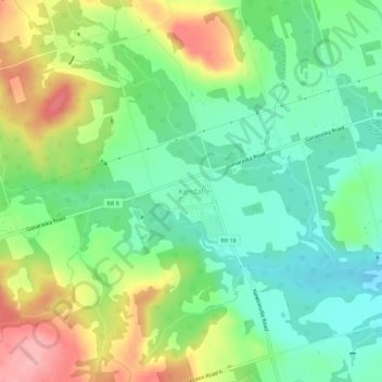
Name: Kendal topographic map, elevation, terrain.
Average elevation: 221 m
Minimum elevation: 168 m
Maximum elevation: 309 m
Make a donation
Gear up for your next adventure:
As an Amazon Associate, this site earns from qualifying purchases at no extra cost to you.
Other topographic maps
Click on a map to view its topography, its elevation and its terrain.
Darlington Provincial Park
Canada > Ontario > Durham Region > Clarington
Darlington Provincial Park is a provincial park in Ontario, Canada. It is located just south of Highway 401 in the city of Bowmanville. A small park, the topography is dominated by gentle hills formed by a terminal moraine deposited by glaciers at the end of the last Ice Age. The park borders on the northern…
Average elevation: 84 m