
Granollers topographic map
Interactive map
Click on the map to display elevation.
About this map
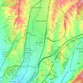
Name: Granollers topographic map, elevation, terrain.
Location: Granollers, Vallès Oriental, Barcelona, Catalonia, Spain (41.56427 2.25644 41.62258 2.30401)
Average elevation: 150 m
Minimum elevation: 87 m
Maximum elevation: 259 m
Other topographic maps
Click on a map to view its topography, its elevation and its terrain.
les Agudes
Spain > Catalonia > Vallès Oriental > Montseny
Les Agudes is a mountain of Catalonia, Spain. It has an elevation of 1,706 metres (5,597 ft) above sea level. It is straddling the municipalities of Arbúcies in the Selva comarca and Fogars de Montclús and Montseny in the Vallès Oriental.
Average elevation: 1,288 m