
Make a donation
Gear up for your next adventure:
As an Amazon Associate, this site earns from qualifying purchases at no extra cost to you.
Ridgeland topographic map
Click on the map to display elevation.
Make a donation
Gear up for your next adventure:
As an Amazon Associate, this site earns from qualifying purchases at no extra cost to you.
Ridgeland
Ridgeland is in northeastern Jasper County, with the center of town sitting on a low ridge at an elevation of 62 feet (19 m) above sea level. According to the United States Census Bureau, the town has a total area of 44.7 square miles (115.8 km2), of which 44.4 square miles (115.1 km2) are land and 0.3 square miles (0.7 km2), or 0.59%, are water. The town's area as of 2010 was 18 times greater than its 2000 area of 2.4 square miles (6.3 km2). The town limits now extend east into Beaufort County as far as the west bank of the Broad River.
Make a donation
Gear up for your next adventure:
As an Amazon Associate, this site earns from qualifying purchases at no extra cost to you.
About this map
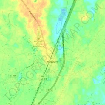
Name: Ridgeland topographic map, elevation, terrain.
Location: Ridgeland, Jasper County, South Carolina, United States (32.44908 -80.99926 32.52542 -80.95989)
Average elevation: 15 m
Minimum elevation: -3 m
Maximum elevation: 32 m
Make a donation
Gear up for your next adventure:
As an Amazon Associate, this site earns from qualifying purchases at no extra cost to you.
Other topographic maps
Click on a map to view its topography, its elevation and its terrain.
Make a donation
Gear up for your next adventure:
As an Amazon Associate, this site earns from qualifying purchases at no extra cost to you.
Latitude Margaritaville
United States > South Carolina > Jasper County > Hardeeville
Average elevation: 4 m