Geolocate

Sorell topographic map

Click on the map to display elevation.

About this map

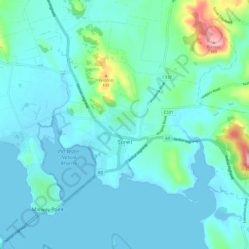
Name: Sorell topographic map, elevation, terrain.

Location: Sorell, Hobart, Sorell, Tasmania, 7172, Australia (-42.80109 147.53460 -42.75450 147.63644)

Average elevation: 32 m

Minimum elevation: -1 m

Maximum elevation: 232 m

Other topographic maps

Click on a map to view its topography, its elevation and its terrain.

Selfs Point

Australia > Tasmania > Hobart

Average elevation: 17 m

Waterworks Reserve

Australia > Tasmania > Hobart

Average elevation: 240 m

James Austin Park

Australia > Tasmania > Hobart

Average elevation: 25 m

Perrins Ridge

Australia > Tasmania > Hobart

Average elevation: 467 m

Cartwright Point

Australia > Tasmania > Hobart

Average elevation: 59 m

Mount Direction

Australia > Tasmania > Hobart

Average elevation: 166 m

Glebe Hill

Australia > Tasmania > Hobart

Average elevation: 66 m

Knocklofty

Australia > Tasmania > Hobart

Average elevation: 185 m

Snug Falls

Australia > Tasmania > Hobart > Snug

Average elevation: 336 m

Tolosa Park

Australia > Tasmania > Hobart

Average elevation: 182 m

Glenrose Park

Australia > Tasmania > Hobart

Average elevation: 181 m

Gear up for your next adventure:

🚰Hydration Packs - Hands‑free water storage for hikers
🧦Merino Wool Socks - Moisture-wicking and blister-preventing trail socks
🎁Outdoor Gift Ideas - Great gifts for adventurers
💳Travel Cards for Ireland - Convenient payment abroad
🎒Surveyor High-Vis Vests - Multi-pocket safety vests for field professionals

As an Amazon Associate, this site earns from qualifying purchases at no extra cost to you.