
Make a donation
Gear up for your next adventure:
As an Amazon Associate, this site earns from qualifying purchases at no extra cost to you.
Landshut topographic map
Click on the map to display elevation.
Make a donation
Gear up for your next adventure:
As an Amazon Associate, this site earns from qualifying purchases at no extra cost to you.
Landshut
Landshut befindet sich im Zentrum des Unterbayerischen Hügellandes (allgemeiner auch „Tertiärhügelland“), das sich von der Donau im Norden bis an die Grenze der Münchner Schotterebene im Süden erstreckt; die Stadt gehört also zum Alpenvorland. Das tertiäre Hügelland wird im Stadtgebiet von Landshut durch das Flussbett der Isar unterbrochen. Der Großteil des bebauten Gebietes liegt auf den flachen Terrassen-Ablagerungen des Flusses im Isartal. Die Isar teilt Landshut in drei große städtische Gebiete: einen nördlichen Teil im Isar-Donau-Hügelland, einen südlichen Teil im Isar-Inn-Hügelland sowie die Mühleninsel im Stadtzentrum. Die südlichen Bezirke der Stadt werden durch eine zum Teil steil ansteigende Hügelkette begrenzt, von der der Hofberg mit einer Höhe von 505 Metern über NN den höchsten Punkt des Stadtgebiets bildet. Südwestlich des bebauten Gebietes in Richtung Moosburg befindet sich die Vogelfreistätte Mittlere Isarstauseen, die zu den wertvollsten Wasservogelschutzgebieten Bayerns zählt. An der unteren Isar östlich des Stadtgebiets schließen sich weitere künstlich angelegte Seen an, von denen der Stausee Altheim, der Stausee Niederaichbach sowie die Badeseen Gretlmühle die bedeutendsten sind. Nördlich der Isar durchzieht die Flutmulde Landshut, die – wie der Name bereits sagt – bei Hochwasser geflutet wird und infolgedessen den eigentlichen Flusslauf in Gefahrensituationen entlastet, die Stadt. Im ungefluteten Zustand ist die Flutmulde eine der beliebtesten Parkanlagen Landshuts.
Make a donation
Gear up for your next adventure:
As an Amazon Associate, this site earns from qualifying purchases at no extra cost to you.
About this map
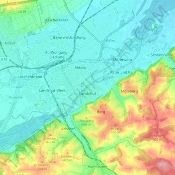
Name: Landshut topographic map, elevation, terrain.
Location: Landshut, Bayern, Deutschland (48.51128 12.10935 48.56537 12.20771)
Average elevation: 422 m
Minimum elevation: 382 m
Maximum elevation: 524 m
Make a donation
Gear up for your next adventure:
As an Amazon Associate, this site earns from qualifying purchases at no extra cost to you.
Other topographic maps
Click on a map to view its topography, its elevation and its terrain.
Landshut
Deutschland > Bayern > Landshut > Landshut
Landshut befindet sich im Zentrum des Unterbayerischen Hügellandes (allgemeiner auch „Tertiärhügelland“), das sich von der Donau im Norden bis an die Grenze der Münchner Schotterebene im Süden erstreckt; die Stadt gehört also zum Alpenvorland. Das tertiäre Hügelland wird im Stadtgebiet von Landshut…
Average elevation: 427 m