
Make a donation
Gear up for your next adventure:
As an Amazon Associate, this site earns from qualifying purchases at no extra cost to you.
Zamami topographic map
Click on the map to display elevation.
Make a donation
Gear up for your next adventure:
As an Amazon Associate, this site earns from qualifying purchases at no extra cost to you.
Zamami
The islands are quite mountainous. Zamami Island has an observatory atop its central mountain, Takatsukiyama. Aka and Geruma islands are just as hilly. Like much of the rest of Japan, the steep topography leaves relatively little level land for agriculture and inhabitation.
Make a donation
Gear up for your next adventure:
As an Amazon Associate, this site earns from qualifying purchases at no extra cost to you.
About this map
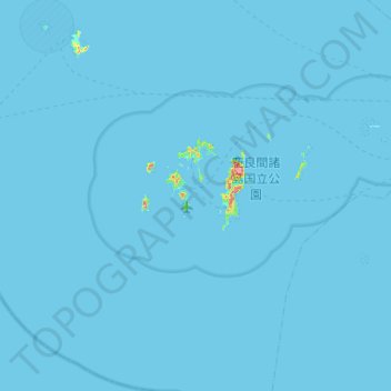
Name: Zamami topographic map, elevation, terrain.
Location: Zamami, Shimajiri, Okinawa Prefecture, Japan (25.94388 127.00712 26.41825 127.36155)
Average elevation: 1 m
Minimum elevation: 0 m
Maximum elevation: 244 m
Make a donation
Gear up for your next adventure:
As an Amazon Associate, this site earns from qualifying purchases at no extra cost to you.