
Make a donation
Gear up for your next adventure:
As an Amazon Associate, this site earns from qualifying purchases at no extra cost to you.
Majayjay topographic map
Click on the map to display elevation.
Make a donation
Gear up for your next adventure:
As an Amazon Associate, this site earns from qualifying purchases at no extra cost to you.
Majayjay
Majayjay is a geographically landlocked area situated in the southernmost part of Laguna. It nestles at the foot of Mt. Banahaw, and due to its higher altitude at some 2,700+ ft above sea level, the town makes for a popular vacation destination during summer in the Philippines. It was once branded as the 'Summer Capital of the Philippines' 300–400 years ago during the Spanish era, when most of the prominent names in the Spanish colonial Philippines visited the area. Other sights along the streets include the remnants of the said era of Spanish-inspired houses that still stand at periodic key locations, mostly in the town square. Affluent families still have their ancestral houses maintained.
Make a donation
Gear up for your next adventure:
As an Amazon Associate, this site earns from qualifying purchases at no extra cost to you.
About this map
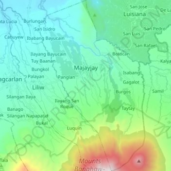
Name: Majayjay topographic map, elevation, terrain.
Location: Majayjay, Laguna, Calabarzon, Philippines (14.06786 121.43648 14.19532 121.51789)
Average elevation: 488 m
Minimum elevation: 43 m
Maximum elevation: 2,136 m
Make a donation
Gear up for your next adventure:
As an Amazon Associate, this site earns from qualifying purchases at no extra cost to you.
Other topographic maps
Click on a map to view its topography, its elevation and its terrain.
Make a donation
Gear up for your next adventure:
As an Amazon Associate, this site earns from qualifying purchases at no extra cost to you.
Make a donation
Gear up for your next adventure:
As an Amazon Associate, this site earns from qualifying purchases at no extra cost to you.
Make a donation
Gear up for your next adventure:
As an Amazon Associate, this site earns from qualifying purchases at no extra cost to you.