
Make a donation
Gear up for your next adventure:
As an Amazon Associate, this site earns from qualifying purchases at no extra cost to you.
Buzău topographic map
Click on the map to display elevation.
Make a donation
Gear up for your next adventure:
As an Amazon Associate, this site earns from qualifying purchases at no extra cost to you.
Buzău
The city is located in the center of the county, 100 km north-east of Bucharest, in the south-east of Romania, taking up a total area of 81,3 km2, at the outermost curvature of the Subcarpathian foothills, at the crossroads of the three main Romanian historical provinces: Wallachia, Transylvania and Moldavia. It is entirely placed on the right bank of Buzău river, which forms its northern limit. The shape of the city is oblong, longer along the river and shorter across. It reaches altitudes of 101 meters in the north-west, near the foothills, going down to 88 meters on the riverbank, while the average altitude of 95 meters is the same as the altitude of Dacia square, in the city center. Thus, Buzău is placed in a flat area, with a height difference of just 10 meters along a 4-kilometer line.
Make a donation
Gear up for your next adventure:
As an Amazon Associate, this site earns from qualifying purchases at no extra cost to you.
About this map
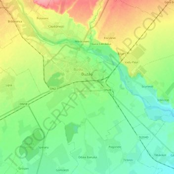
Name: Buzău topographic map, elevation, terrain.
Location: Buzău, Romania (45.09161 26.71469 45.18375 26.92587)
Average elevation: 96 m
Minimum elevation: 66 m
Maximum elevation: 152 m
Make a donation
Gear up for your next adventure:
As an Amazon Associate, this site earns from qualifying purchases at no extra cost to you.
Other topographic maps
Click on a map to view its topography, its elevation and its terrain.