
Ballincolla topographic map
Interactive map
Click on the map to display elevation.
About this map
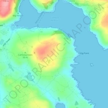
Name: Ballincolla topographic map, elevation, terrain.
Location: Ballincolla, Myross, West Cork, County Cork, Munster, Ireland (51.54471 -9.14136 51.55972 -9.11328)
Average elevation: 27 m
Minimum elevation: 0 m
Maximum elevation: 114 m
County Cork trails, hiking, mountain biking, running and outdoor activities
Other topographic maps
Click on a map to view its topography, its elevation and its terrain.