
Thank you for supporting this site ❤️
Make a donation
Make a donation
Gear up for your next adventure:
As an Amazon Associate, this site earns from qualifying purchases at no extra cost to you.
Bokajan topographic map
Click on the map to display elevation.
Thank you for supporting this site ❤️
Make a donation
Make a donation
Gear up for your next adventure:
As an Amazon Associate, this site earns from qualifying purchases at no extra cost to you.
About this map
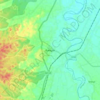
Name: Bokajan topographic map, elevation, terrain.
Location: Bokajan, Diphu, East Karbi Anglong, Assam, 782490, India (25.98351 93.73070 26.06351 93.81070)
Average elevation: 142 m
Minimum elevation: 124 m
Maximum elevation: 182 m
Thank you for supporting this site ❤️
Make a donation
Make a donation
Gear up for your next adventure:
As an Amazon Associate, this site earns from qualifying purchases at no extra cost to you.