Geolocate

Nijmegen topographic map

Click on the map to display elevation.

About this map
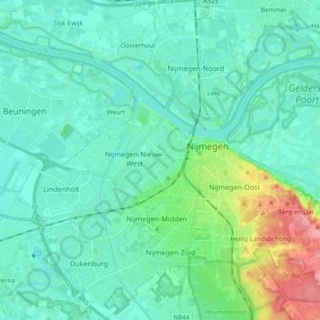
Name: Nijmegen topographic map, elevation, terrain.

Location: Nijmegen, Gelderland, Netherlands (51.79059 5.75762 51.89462 5.90835)

Average elevation: 19 m

Minimum elevation: 3 m

Maximum elevation: 95 m

Other topographic maps

Click on a map to view its topography, its elevation and its terrain.

Nijmegen

Netherlands > Gelderland > Nijmegen

Average elevation: 16 m

Kops Plateau

Netherlands > Gelderland > Nijmegen

Average elevation: 36 m

Gear up for your next adventure:

📦Outdoor Storage Bags - Keep gear organized and dry
⌚Solar Multisport Watches - Advanced mapping and GPS tracking for endurance hikers
🧺Quick-Dry Hiking Towels - Space-saving towels for wild swimming or camping
⛺Ultralight Hiking Tents - Compact shelters for multi-day wild camping in Ireland
🛠️Tent Repair Kits - Fix tents on the trail

As an Amazon Associate, this site earns from qualifying purchases at no extra cost to you.