
Robotyne topographic map
Click on the map to display elevation.
About this map
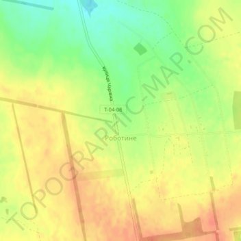
Name: Robotyne topographic map, elevation, terrain.
Average elevation: 138 m
Minimum elevation: 113 m
Maximum elevation: 157 m
Other topographic maps
Click on a map to view its topography, its elevation and its terrain.
Zaporizhzhia
Zaporizhzhia is located in south-eastern Ukraine. The Dnieper splits the city in two; between them is Khortytsia Island. The city covers 334 km2 (129 sq mi) at an elevation of 50 m (160 ft) above sea level. The New and Old Dnieper flow past around Khortytsia: The New Dnieper [uk] is about 800 m (2,600 feet)…
Average elevation: 78 m