
Make a donation
Gear up for your next adventure:
As an Amazon Associate, this site earns from qualifying purchases at no extra cost to you.
Innerbraz topographic map
Click on the map to display elevation.
Make a donation
Gear up for your next adventure:
As an Amazon Associate, this site earns from qualifying purchases at no extra cost to you.
Innerbraz
Der Ort Innerbraz liegt im Klostertal am Fluss Alfenz auf 708 Metern Höhe. Die Gemeinde umfasst das Tal zwischen Außerbraz und Dalaas sowie die Hänge nördlich und südlich davon. Im Norden liegt die Masonalpe, begrenzt durch die Pitschiköpfe (2280 m) und den Schafberg (2413 m). Im Süden steigt das Land im Garnilawald auf rund 1800 Meter an. Auffällig ist, dass die Gemeindegrenze nicht am Höhenrücken, sondern etwa bei der Waldgrenze liegt.
Make a donation
Gear up for your next adventure:
As an Amazon Associate, this site earns from qualifying purchases at no extra cost to you.
About this map
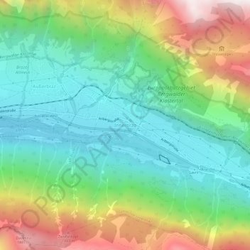
Name: Innerbraz topographic map, elevation, terrain.
Average elevation: 1,111 m
Minimum elevation: 643 m
Maximum elevation: 2,022 m
Make a donation
Gear up for your next adventure:
As an Amazon Associate, this site earns from qualifying purchases at no extra cost to you.