Geolocate

Montgomery topographic map

Click on the map to display elevation.

About this map

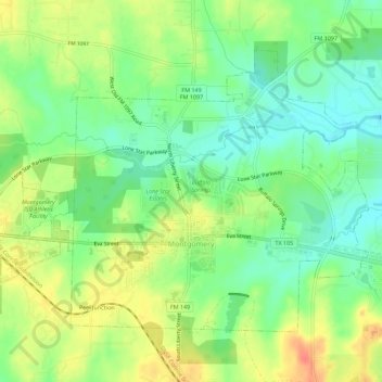
Name: Montgomery topographic map, elevation, terrain.

Location: Montgomery, Montgomery County, Texas, United States (30.37704 -95.72645 30.41285 -95.67018)

Average elevation: 85 m

Minimum elevation: 63 m

Maximum elevation: 113 m

Other topographic maps

Click on a map to view its topography, its elevation and its terrain.

Bobville

United States > Texas > Montgomery County

Average elevation: 75 m

New Caney

United States > Texas > Montgomery County

Average elevation: 30 m

Mount Zion

United States > Texas > Montgomery County

Average elevation: 88 m

Security

United States > Texas > Montgomery County

Average elevation: 53 m

Conroe

United States > Texas > Montgomery County > Conroe > Conroe

Average elevation: 60 m

Porter

United States > Texas > Montgomery County

Average elevation: 30 m

Lake Egypt

United States > Texas > Montgomery County > Egypt

Average elevation: 61 m

New Caney

United States > Texas > Montgomery County

Average elevation: 30 m

Gear up for your next adventure:

🌿Irish Flora Guides - Identify plants while exploring the countryside
🪓Camping Axes & Hatchets - Wood cutting tools for campsite prep
🧭Route Planning Books - Plan the best hiking routes
🐦Irish Bird Guides - Spot coastal and mountain birds during your hike
🔌Fast Car Chargers - Recharge GPS and phones between trailheads

As an Amazon Associate, this site earns from qualifying purchases at no extra cost to you.