
Thank you for supporting this site ❤️
Make a donation
Make a donation
Gear up for your next adventure:
As an Amazon Associate, this site earns from qualifying purchases at no extra cost to you.
Tojo topographic map
Click on the map to display elevation.
Thank you for supporting this site ❤️
Make a donation
Make a donation
Gear up for your next adventure:
As an Amazon Associate, this site earns from qualifying purchases at no extra cost to you.
About this map
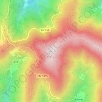
Name: Tojo topographic map, elevation, terrain.
Location: Tojo, Piódão, Arganil, Coimbra, 3305-242, Portugal (40.21581 -7.84849 40.21591 -7.84839)
Average elevation: 991 m
Minimum elevation: 628 m
Maximum elevation: 1,277 m
Thank you for supporting this site ❤️
Make a donation
Make a donation
Gear up for your next adventure:
As an Amazon Associate, this site earns from qualifying purchases at no extra cost to you.