
Make a donation
Gear up for your next adventure:
As an Amazon Associate, this site earns from qualifying purchases at no extra cost to you.
Baiyin topographic map
Click on the map to display elevation.
Make a donation
Gear up for your next adventure:
As an Amazon Associate, this site earns from qualifying purchases at no extra cost to you.
Baiyin
Baiyin is part loess plateau, part desert. Elevation ranges from 1,275 to 3,321 meters (4,183 to 10,896 feet) above sea-level. The climate is very arid with only 110–352 mm (4.3–13.9 in) of annual precipitation. Annual evaporation is 2,101 mm (82.7 in) resulting in a net loss of approximately 1,800 mm (71 in). The Yellow River flows from south to north for 214 km (133 mi) through Baiyin.
Make a donation
Gear up for your next adventure:
As an Amazon Associate, this site earns from qualifying purchases at no extra cost to you.
About this map
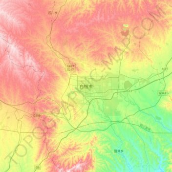
Name: Baiyin topographic map, elevation, terrain.
Location: Baiyin, Baiyin District, Baiyin City, Gansu, China (36.38516 103.97554 36.70516 104.29554)
Average elevation: 1,836 m
Minimum elevation: 1,460 m
Maximum elevation: 2,239 m
Make a donation
Gear up for your next adventure:
As an Amazon Associate, this site earns from qualifying purchases at no extra cost to you.