
Thank you for supporting this site ❤️
Make a donation
Make a donation
Gear up for your next adventure:
As an Amazon Associate, this site earns from qualifying purchases at no extra cost to you.
Cicera topographic map
Click on the map to display elevation.
Thank you for supporting this site ❤️
Make a donation
Make a donation
Gear up for your next adventure:
As an Amazon Associate, this site earns from qualifying purchases at no extra cost to you.
About this map
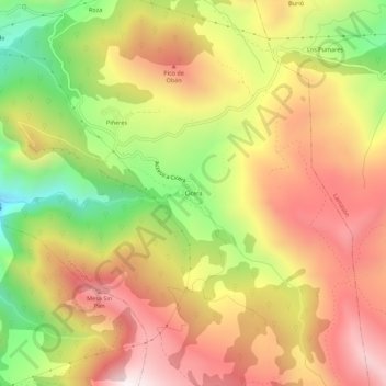
Name: Cicera topographic map, elevation, terrain.
Location: Cicera, Peñarrubia, Saja-Nansa, Cantabria, 39580, Spain (43.21614 -4.57034 43.25614 -4.53034)
Average elevation: 666 m
Minimum elevation: 177 m
Maximum elevation: 1,072 m
Thank you for supporting this site ❤️
Make a donation
Make a donation
Gear up for your next adventure:
As an Amazon Associate, this site earns from qualifying purchases at no extra cost to you.