Geolocate

Bridgnorth topographic map

Click on the map to display elevation.

Gear up for your next adventure:

As an Amazon Associate, this site earns from qualifying purchases at no extra cost to you.

Bridgnorth

The town is in the Severn Valley, where the river passes through a relatively narrow valley with largely-wooded slopes. High Town, the part of the town sited on the west side of the Severn, is built on a notable promontory, at the southern end of which the castle was constructed, and is known as Castle Hill. Low Town is on lower-lying ground on the banks of the river. High Town is at an elevation of 65–68 metres (213–223 feet) above sea level, whilst Low Town is at 32–33 metres (105 feet). The lie of the land of Low Town is less hilly but then rises steeply to its immediate east.

Wikipedia (CC-BY-SA 3.0)

👉 Easily get elevation data in JSON, GeoTIFF and KML formats using Elevation API
Thank you for supporting this site ❤️
Make a donation

Gear up for your next adventure:

As an Amazon Associate, this site earns from qualifying purchases at no extra cost to you.

About this map

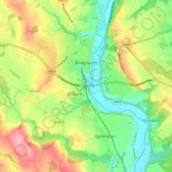
Name: Bridgnorth topographic map, elevation, terrain.

Location: Bridgnorth, Shropshire, England, United Kingdom (52.50577 -2.45650 52.54888 -2.36913)

Average elevation: 80 m

Minimum elevation: 25 m

Maximum elevation: 154 m

👉 Easily get elevation data in JSON, GeoTIFF and KML formats using Elevation API
Thank you for supporting this site ❤️
Make a donation

Gear up for your next adventure:

As an Amazon Associate, this site earns from qualifying purchases at no extra cost to you.

Other topographic maps

Click on a map to view its topography, its elevation and its terrain.

Waterloo

United Kingdom > England > Shropshire > Whixall

Average elevation: 95 m

Croesau Bach

United Kingdom > England > Shropshire > Trefonen

Average elevation: 247 m

Alveley

United Kingdom > England > Shropshire

Average elevation: 102 m

Whitchurch

United Kingdom > England > Shropshire

Average elevation: 100 m

Whitchurch

United Kingdom > England > Shropshire

Average elevation: 100 m

Thank you for supporting this site ❤️
Make a donation

Gear up for your next adventure:

As an Amazon Associate, this site earns from qualifying purchases at no extra cost to you.

Tilstock

United Kingdom > England > Shropshire

Average elevation: 104 m

Hook-a-Gate

United Kingdom > England > Shropshire

Average elevation: 98 m

Trefonen

United Kingdom > England > Shropshire

Average elevation: 204 m

Coundmoor

United Kingdom > England > Shropshire

Average elevation: 107 m

Llanymynech

United Kingdom > England > Shropshire

Average elevation: 88 m

Thank you for supporting this site ❤️
Make a donation

Gear up for your next adventure:

As an Amazon Associate, this site earns from qualifying purchases at no extra cost to you.

Dryton

United Kingdom > England > Shropshire > Eyton on Severn

Average elevation: 70 m

Bromdon

United Kingdom > England > Shropshire

Average elevation: 271 m

Pennerley

United Kingdom > England > Shropshire > Stiperstones

Average elevation: 353 m

Fauls

United Kingdom > England > Shropshire

Average elevation: 90 m

Thank you for supporting this site ❤️
Make a donation

Gear up for your next adventure:

As an Amazon Associate, this site earns from qualifying purchases at no extra cost to you.

Chirbury

United Kingdom > England > Shropshire

Average elevation: 125 m

Oswestry

United Kingdom > England > Shropshire

Average elevation: 158 m

Clee Burf

United Kingdom > England > Shropshire

Average elevation: 385 m

Kenstone

United Kingdom > England > Shropshire > Hodnet

Average elevation: 122 m

Ticklerton

United Kingdom > England > Shropshire

Average elevation: 198 m

Upton Magna

United Kingdom > England > Shropshire

Average elevation: 71 m

Wem

United Kingdom > England > Shropshire

Average elevation: 88 m

Thank you for supporting this site ❤️
Make a donation

Gear up for your next adventure:

As an Amazon Associate, this site earns from qualifying purchases at no extra cost to you.

Chapel Lawn

United Kingdom > England > Shropshire

Average elevation: 309 m

Bomere Heath

United Kingdom > England > Shropshire

Average elevation: 94 m

Stiperstones

United Kingdom > England > Shropshire

Average elevation: 401 m

Plealey

United Kingdom > England > Shropshire

Average elevation: 126 m

Stiperstones

United Kingdom > England > Shropshire

Average elevation: 401 m

Benthall

United Kingdom > England > Shropshire

Average elevation: 142 m

Clee Hill

United Kingdom > England > Shropshire

Average elevation: 403 m

Harmer Hill

United Kingdom > England > Shropshire

Average elevation: 101 m

Bentlawnt

United Kingdom > England > Shropshire

Average elevation: 256 m

Thank you for supporting this site ❤️
Make a donation

Gear up for your next adventure:

As an Amazon Associate, this site earns from qualifying purchases at no extra cost to you.

Whitchurch

United Kingdom > England > Shropshire

Average elevation: 100 m

Brockton

United Kingdom > England > Shropshire

Average elevation: 213 m

Chirbury

United Kingdom > England > Shropshire

Average elevation: 125 m

Newton

United Kingdom > England > Shropshire > Ellesmere

Average elevation: 99 m

Treflach

United Kingdom > England > Shropshire

Average elevation: 176 m

Snailbeach

United Kingdom > England > Shropshire

Average elevation: 248 m

Soudley

United Kingdom > England > Shropshire > Cheswardine

Average elevation: 116 m

Lyth Hill

United Kingdom > England > Shropshire > Longden

Average elevation: 108 m

Hindford

United Kingdom > England > Shropshire

Average elevation: 99 m

English Frankton

United Kingdom > England > Shropshire

Average elevation: 93 m

Highley

United Kingdom > England > Shropshire

Average elevation: 80 m

Thank you for supporting this site ❤️
Make a donation

Gear up for your next adventure:

As an Amazon Associate, this site earns from qualifying purchases at no extra cost to you.

Calcott

United Kingdom > England > Shropshire > Bicton

Average elevation: 77 m

Farmcote

United Kingdom > England > Shropshire > Claverley

Average elevation: 96 m

Hanwood Bank

United Kingdom > England > Shropshire > Hanwood

Average elevation: 92 m

Quatford

United Kingdom > England > Shropshire > Bridgnorth

Average elevation: 69 m

Walford Heath

United Kingdom > England > Shropshire > Walford

Average elevation: 84 m

Thank you for supporting this site ❤️
Make a donation

Gear up for your next adventure:

As an Amazon Associate, this site earns from qualifying purchases at no extra cost to you.

Wroxeter

United Kingdom > England > Shropshire

Average elevation: 61 m

Bushmoor

United Kingdom > England > Shropshire

Average elevation: 189 m

Plowden

United Kingdom > England > Shropshire > Lydbury North

Average elevation: 223 m

Meadowtown

United Kingdom > England > Shropshire

Average elevation: 218 m

Thank you for supporting this site ❤️
Make a donation

Gear up for your next adventure:

As an Amazon Associate, this site earns from qualifying purchases at no extra cost to you.

Marton

United Kingdom > England > Shropshire

Average elevation: 92 m

Stiperstones

United Kingdom > England > Shropshire

Average elevation: 327 m

Brown Clee Hill

United Kingdom > England > Shropshire

Average elevation: 385 m

Selattyn

United Kingdom > England > Shropshire

Average elevation: 242 m

Thank you for supporting this site ❤️
Make a donation

Gear up for your next adventure:

As an Amazon Associate, this site earns from qualifying purchases at no extra cost to you.

Pant-glas

United Kingdom > England > Shropshire > Oswestry

Average elevation: 223 m

Dudleston

United Kingdom > England > Shropshire

Average elevation: 100 m

Ash Magna

United Kingdom > England > Shropshire

Average elevation: 108 m

Bagginswood

United Kingdom > England > Shropshire > Stottesdon

Average elevation: 160 m

Thank you for supporting this site ❤️
Make a donation

Gear up for your next adventure:

As an Amazon Associate, this site earns from qualifying purchases at no extra cost to you.

Burrow

United Kingdom > England > Shropshire > Hopesay

Average elevation: 218 m

Chavel

United Kingdom > England > Shropshire > Ford

Average elevation: 83 m

Weston

United Kingdom > England > Shropshire > Oswestry

Average elevation: 114 m

Maesbrook

United Kingdom > England > Shropshire

Average elevation: 66 m

Myddle

United Kingdom > England > Shropshire

Average elevation: 94 m

Thank you for supporting this site ❤️
Make a donation

Gear up for your next adventure:

As an Amazon Associate, this site earns from qualifying purchases at no extra cost to you.

Overton

United Kingdom > England > Shropshire

Average elevation: 136 m

Derrington

United Kingdom > England > Shropshire > Ditton Priors

Average elevation: 219 m

Morda

United Kingdom > England > Shropshire

Average elevation: 132 m

Colemere

United Kingdom > England > Shropshire

Average elevation: 96 m

Sleap

United Kingdom > England > Shropshire > Wem

Average elevation: 85 m

Thank you for supporting this site ❤️
Make a donation

Gear up for your next adventure:

As an Amazon Associate, this site earns from qualifying purchases at no extra cost to you.

Wern

United Kingdom > England > Shropshire > Weston Rhyn

Average elevation: 162 m

Park Hall

United Kingdom > England > Shropshire

Average elevation: 112 m

Nantmawr

United Kingdom > England > Shropshire

Average elevation: 166 m

Callow Hill

United Kingdom > England > Shropshire > Diddlebury

Average elevation: 215 m

Thank you for supporting this site ❤️
Make a donation

Gear up for your next adventure:

As an Amazon Associate, this site earns from qualifying purchases at no extra cost to you.

Knowbury

United Kingdom > England > Shropshire

Average elevation: 225 m

Calverhall

United Kingdom > England > Shropshire

Average elevation: 99 m

Wolverley

United Kingdom > England > Shropshire > Newtown

Average elevation: 88 m

Pipe Gate

United Kingdom > England > Shropshire

Average elevation: 128 m

Garmston

United Kingdom > England > Shropshire > Leighton

Average elevation: 97 m

Thank you for supporting this site ❤️
Make a donation

Gear up for your next adventure:

As an Amazon Associate, this site earns from qualifying purchases at no extra cost to you.

Farden

United Kingdom > England > Shropshire > Bitterley

Average elevation: 245 m

Lower Forge

United Kingdom > England > Shropshire > Eardington

Average elevation: 69 m

Stapeley Hill

United Kingdom > England > Shropshire

Average elevation: 311 m

Clun

United Kingdom > England > Shropshire

Average elevation: 284 m

Ellesmere

United Kingdom > England > Shropshire

Average elevation: 94 m

Whitcliffe

United Kingdom > England > Shropshire > Ludford

Average elevation: 132 m

Kempton

United Kingdom > England > Shropshire

Average elevation: 208 m

Alberbury

United Kingdom > England > Shropshire

Average elevation: 88 m

Grimpo

United Kingdom > England > Shropshire

Average elevation: 91 m

Bronygarth

United Kingdom > England > Shropshire

Average elevation: 196 m

Thank you for supporting this site ❤️
Make a donation

Gear up for your next adventure:

As an Amazon Associate, this site earns from qualifying purchases at no extra cost to you.

Gear up for your next adventure:

🛌Cold Weather Sleeping Bags - Warm sleeping bags for colder hikes
📱Rugged Smartphones - Waterproof phones with long battery for offline mapping
🚲Cycling GPS Computers - Topographic mapping for Irish road and mountain biking

As an Amazon Associate, this site earns from qualifying purchases at no extra cost to you.