
Make a donation
Gear up for your next adventure:
As an Amazon Associate, this site earns from qualifying purchases at no extra cost to you.
Pfänder topographic map
Click on the map to display elevation.
Make a donation
Gear up for your next adventure:
As an Amazon Associate, this site earns from qualifying purchases at no extra cost to you.
Pfänder
Der Pfänder ist der zweithöchste Punkt des Höhenrückens, der sich im Osten des Bodensees, oberhalb von Bregenz und Lochau, über eine Strecke von etwa 5 Kilometern hinzieht. Der höchste Gipfel der Kette ist der Hochberg (1069 m).
Make a donation
Gear up for your next adventure:
As an Amazon Associate, this site earns from qualifying purchases at no extra cost to you.
About this map
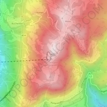
Name: Pfänder topographic map, elevation, terrain.
Location: Pfänder, Lochau, Bezirk Bregenz, Vorarlberg, 6911, Österreich (47.50732 9.78015 47.50742 9.78025)
Average elevation: 826 m
Minimum elevation: 476 m
Maximum elevation: 1,055 m
Make a donation
Gear up for your next adventure:
As an Amazon Associate, this site earns from qualifying purchases at no extra cost to you.
Other topographic maps
Click on a map to view its topography, its elevation and its terrain.