
Make a donation
Gear up for your next adventure:
As an Amazon Associate, this site earns from qualifying purchases at no extra cost to you.
Herbignac topographic map
Click on the map to display elevation.
Make a donation
Gear up for your next adventure:
As an Amazon Associate, this site earns from qualifying purchases at no extra cost to you.
About this map
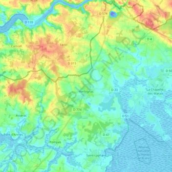
Name: Herbignac topographic map, elevation, terrain.
Average elevation: 16 m
Minimum elevation: -35 m
Maximum elevation: 58 m
Make a donation
Gear up for your next adventure:
As an Amazon Associate, this site earns from qualifying purchases at no extra cost to you.
Other topographic maps
Click on a map to view its topography, its elevation and its terrain.
La Vieille-Ville
France > Pays de la Loire > Loire-Atlantique > La Chapelle-Glain
Average elevation: 72 m
La Grande Ragotière
France > Pays de la Loire > Loire-Atlantique > La Regrippière
Average elevation: 80 m
Make a donation
Gear up for your next adventure:
As an Amazon Associate, this site earns from qualifying purchases at no extra cost to you.
Réserve naturelle de la Pointe Saint-Gildas
France > Pays de la Loire > Loire-Atlantique > Préfailles
Average elevation: 2 m
Le Port Cormier
France > Pays de la Loire > Loire-Atlantique > Nort-sur-Erdre > Le Port Cormier
Average elevation: 13 m
Make a donation
Gear up for your next adventure:
As an Amazon Associate, this site earns from qualifying purchases at no extra cost to you.
Le Bout des Ponts
France > Pays de la Loire > Loire-Atlantique > Guémené-Penfao
Average elevation: 30 m
Make a donation
Gear up for your next adventure:
As an Amazon Associate, this site earns from qualifying purchases at no extra cost to you.