
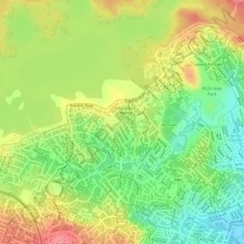
Nagkakaisang Molave HOA topographic map
Interactive map
Click on the map to display elevation.
About this map
Name: Nagkakaisang Molave HOA topographic map, elevation, terrain.
Average elevation: 63 m
Minimum elevation: 20 m
Maximum elevation: 102 m
Other topographic maps
Click on a map to view its topography, its elevation and its terrain.
UP Campus
UP Campus, Diliman, 4th District, Quezon City, Eastern Manila District, Metro Manila, 1101, Philippines
Average elevation: 59 m
San Francisco del Monte
San Francisco del Monte, 1st District, Quezon City, Eastern Manila District, Metro Manila, 1100, Philippines
Average elevation: 21 m
Cubao
Cubao, 3rd District, Quezon City, Eastern Manila District, Metro Manila, 1100, Philippines
Average elevation: 42 m
Diliman Creek
Diliman Creek, Roxas, Project 1, 4th District, Quezon City, Eastern Manila District, Metro Manila, 1103, Philippines
Average elevation: 23 m
N.S. Amoranto
N.S. Amoranto, La Loma, 1st District, Quezon City, Eastern Manila District, Metro Manila, 1100, Philippines
Average elevation: 14 m
Escopa III
Escopa III, Project 4, 3rd District, Quezon City, Eastern Manila District, Metro Manila, 1109, Philippines
Average elevation: 39 m
UP Biology Threatened Species Arboretum
UP Biology Threatened Species Arboretum, UP Campus, Diliman, 4th District, Quezon City, Eastern Manila District, Metro Manila, 1101, Philippines
Average elevation: 62 m
Novaliches Proper
Novaliches Proper, 5th District, Quezon City, Eastern Manila District, Metro Manila, 1123, Philippines
Average elevation: 46 m
Holy Spirit
Holy Spirit, 2nd District, Quezon City, Eastern Manila District, Metro Manila, 1100, Philippines
Average elevation: 71 m
Bayanihan
Bayanihan, Project 4, 3rd District, Quezon City, Eastern Manila District, Metro Manila, 1109, Philippines
Average elevation: 39 m
Matandang Balara
Matandang Balara, Quezon City, Eastern Manila District, Metro Manila, 1119, Philippines
Average elevation: 63 m
Bernardo Park
Bernardo Park, Kamuning, Project 1, Quezon City, Metro Manila, 1103, Philippines
Average elevation: 41 m
Manresa
Manresa, 1st District, Quezon City, Eastern Manila District, Metro Manila, 1100, Philippines
Average elevation: 17 m
Amihan
Amihan, Project 3, Quezon City, Metro Manila, 1102, Philippines
Average elevation: 47 m
Villa Verde Creek
Villa Verde Creek, Villa Verde Homes, 5th District, Quezon City, Eastern Manila District, Metro Manila, 1100, Philippines
Average elevation: 51 m
Tullahan River
Tullahan River, 5th District, Quezon City, Second District, 1125, Philippines
Average elevation: 39 m
Balintawak
Balintawak, 6th District, Quezon City, Eastern Manila District, Metro Manila, 1100, Philippines
Average elevation: 22 m
La Mesa Eco Park
La Mesa Eco Park, Novaliches Reservoir, 5th District, Quezon City, Eastern Manila District, Metro Manila, 1118, Philippines
Average elevation: 66 m
Tandang Sora
Tandang Sora, 6th District, Quezon City, Eastern Manila District, Metro Manila, 1116, Philippines
Average elevation: 43 m
Purok Aguinaldo
Purok Aguinaldo, Village B, UP Campus, Diliman, 4th District, Quezon City, Eastern Manila District, Metro Manila, 1101, Philippines
Average elevation: 59 m
Culiat Creek
Culiat Creek, Culiat, Vasra, 1st District, Quezon City, Eastern Manila District, Metro Manila, 1128, Philippines
Average elevation: 44 m
Quezon City Hall Park and Lagoon
Quezon City Hall Park and Lagoon, Central, Diliman, 4th District, Quezon City, Eastern Manila District, Metro Manila, 1100, Philippines
Average elevation: 49 m
Nagkaisang Nayon
Nagkaisang Nayon, 5th District, Quezon City, Eastern Manila District, Metro Manila, 1125, Philippines
Average elevation: 41 m
Greater Lagro
Greater Lagro, 5th District, Quezon City, Eastern Manila District, Metro Manila, 1118, Philippines
Average elevation: 69 m
Baesa
Baesa, 6th District, Quezon City, Eastern Manila District, Metro Manila, 1106, Philippines
Average elevation: 25 m
Tullahan River
Tullahan River, 5th District, Quezon City, Eastern Manila District, Metro Manila, 1100, Philippines
Average elevation: 39 m
La Mesa Dam
La Mesa Dam, Greater Lagro, Novaliches Reservoir, 5th District, Quezon City, Eastern Manila District, Metro Manila, 1118, Philippines
Average elevation: 65 m
Villa Maria Clara
Villa Maria Clara, Project 4, 3rd District, Quezon City, Eastern Manila District, Metro Manila, 1109, Philippines
Average elevation: 40 m
Project 3
Project 3, 3rd District, Quezon City, Eastern Manila District, Metro Manila, 1100, Philippines
Average elevation: 48 m
Central
Central, Diliman, 4th District, Quezon City, Eastern Manila District, Metro Manila, 1100, Philippines
Average elevation: 50 m
Bagong Silangan
Bagong Silangan, Quezon City, Eastern Manila District, Metro Manila, 1100, Philippines
Average elevation: 48 m
Krus na Ligas
Krus na Ligas, Quezon City, 4th District, Quezon City, Metro Manila, 1101, Philippines
Average elevation: 55 m
Quezon Memorial Circle
Philippines > Quezon City > Pinyahan
Quezon Memorial Circle, Pinyahan, Quezon City, 4th District, Quezon City, Metro Manila, 1100, Philippines
Average elevation: 49 m
Pasong Putik Proper
Pasong Putik Proper, 5th District, Quezon City, Second District, Metro Manila, 1118, Philippines
Average elevation: 75 m
Diliman
Diliman, Quezon City, Metro Manila, 1100, Philippines, Quezon Memorial Circle
Average elevation: 49 m
Sikatuna Village 2
Philippines > Quezon City > Sikatuna Village 2
Sikatuna Village 2, 5th District, Quezon City, Eastern Manila District, Metro Manila, 274, Philippines
Average elevation: 38 m
Damayan
Damayan, San Francisco del Monte, 1st District, Quezon City, Eastern Manila District, Metro Manila, 1104, Philippines
Average elevation: 18 m
Unang Sigaw
Unang Sigaw, Balintawak, 6th District, Quezon City, Eastern Manila District, Metro Manila, 1106, Philippines
Average elevation: 22 m
La Mesa Eco Park
La Mesa Eco Park, Novaliches Reservoir, 5th District, Quezon City, Eastern Manila District, Metro Manila, 1118, Philippines
Average elevation: 66 m
SB Kingspoint Park
SB Kingspoint Park, Goodwill Homes 2, Bagbag, 5th District, Quezon City, Eastern Manila District, Metro Manila, 1116, Philippines
Average elevation: 34 m
Pasong Tamo
Pasong Tamo, 6th District, Quezon City, Eastern Manila District, Metro Manila, 1107, Philippines
Average elevation: 58 m
White Plains
White Plains, 3rd District, Quezon City, Eastern Manila District, Metro Manila, 1110, Philippines
Average elevation: 31 m
Commonwealth
Commonwealth, 2nd District, Quezon City, Eastern Manila District, Metro Manila, 1100, Philippines
Average elevation: 72 m
Gulod
Gulod, Quezon City, 5th District, Second District, Metro Manila, 1117, Philippines
Average elevation: 43 m
Veterans Village
Veterans Village, 1st District, Quezon City, Eastern Manila District, Metro Manila, 1105, Philippines
Average elevation: 28 m
Batasan Hills
Batasan Hills, Quezon City, Metro Manila, 1100, Philippines
Average elevation: 49 m
Project 2
Project 2, 3rd District, Quezon City, Eastern Manila District, Metro Manila, 1100, Philippines
Average elevation: 50 m
Loyola Heights
Loyola Heights, 3rd District, Quezon City, Eastern Manila District, Metro Manila, 1108, Philippines
Average elevation: 46 m
Pinyahan
Pinyahan, Diliman, 4th District, Quezon City, Eastern Manila District, Metro Manila, 1100, Philippines
Average elevation: 47 m
Teachers Village East
Teachers Village East, Quezon City, 4th District, Quezon City, Metro Manila, 1101, Philippines
Average elevation: 54 m