Geolocate

Medway River topographic map

Interactive map

Click on the map to display elevation.

About this map

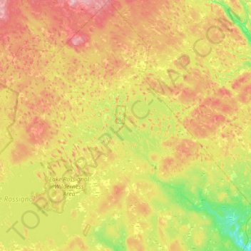
Name: Medway River topographic map, elevation, terrain.

Location: Medway River, Municipality of the County of Annapolis, Queens County, Nova Scotia, Canada (44.13356 -65.13836 44.53700 -64.62356)

Average elevation: 96 m

Minimum elevation: 0 m

Maximum elevation: 223 m

Other topographic maps

Click on a map to view its topography, its elevation and its terrain.

Godfrey Lake

Canada > Nova Scotia > Municipality of the County of Annapolis > Lake Alma

Godfrey Lake, Lake Alma, Municipality of the County of Annapolis, Annapolis County, Nova Scotia, B0S 1A0, Canada

Average elevation: 239 m

Matthews Lake

Canada > Nova Scotia > Municipality of the County of Annapolis > Perotte

Matthews Lake, Perotte, Municipality of the County of Annapolis, Annapolis County, Nova Scotia, B0S 1A0, Canada

Average elevation: 188 m

Victoria Beach

Canada > Nova Scotia > Municipality of the County of Annapolis

Victoria Beach, Municipality of the County of Annapolis, Annapolis County, Nova Scotia, B0S 1A0, Canada

Average elevation: 57 m