
Make a donation
Gear up for your next adventure:
As an Amazon Associate, this site earns from qualifying purchases at no extra cost to you.
Rancagua topographic map
Click on the map to display elevation.
Make a donation
Gear up for your next adventure:
As an Amazon Associate, this site earns from qualifying purchases at no extra cost to you.
About this map
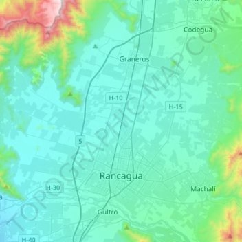
Name: Rancagua topographic map, elevation, terrain.
Location: Rancagua, Provincia de Cachapoal, O'Higgins Region, Chile (-34.21364 -70.94117 -34.02856 -70.67679)
Average elevation: 585 m
Minimum elevation: 406 m
Maximum elevation: 1,839 m
Make a donation
Gear up for your next adventure:
As an Amazon Associate, this site earns from qualifying purchases at no extra cost to you.
Other topographic maps
Click on a map to view its topography, its elevation and its terrain.
El Molino Viejo
Chile > O'Higgins Region > Provincia de Cachapoal > Requínoa > Pichiguao
Average elevation: 373 m
Condominio San José
Chile > O'Higgins Region > Provincia de Cachapoal > Requínoa
Average elevation: 420 m
Make a donation
Gear up for your next adventure:
As an Amazon Associate, this site earns from qualifying purchases at no extra cost to you.
Rinconada de Doñihue Sur
Chile > O'Higgins Region > Provincia de Cachapoal > Doñihue > Rinconada de Doñihue Sur
Average elevation: 400 m