
Make a donation
Gear up for your next adventure:
As an Amazon Associate, this site earns from qualifying purchases at no extra cost to you.
Sogamoso topographic map
Click on the map to display elevation.
Make a donation
Gear up for your next adventure:
As an Amazon Associate, this site earns from qualifying purchases at no extra cost to you.
Sogamoso
Sogamoso (Spanish pronunciation: [soɣaˈmoso]) is a city in the department of Boyacá of Colombia. It is the capital of the Sugamuxi Province, named after the original Sugamuxi. Sogamoso is nicknamed "City of the Sun", based on the original Muisca tradition of pilgrimage and adoring their Sun god Sué at the Sun Temple. The city is located at an altitude of 2,569 metres (8,428 ft) on the Altiplano Cundiboyacense in the Eastern Ranges of the Colombian Andes.
Make a donation
Gear up for your next adventure:
As an Amazon Associate, this site earns from qualifying purchases at no extra cost to you.
About this map
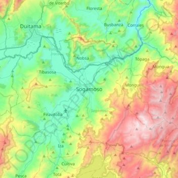
Name: Sogamoso topographic map, elevation, terrain.
Average elevation: 2,901 m
Minimum elevation: 2,357 m
Maximum elevation: 3,987 m
Make a donation
Gear up for your next adventure:
As an Amazon Associate, this site earns from qualifying purchases at no extra cost to you.