
Missoula County topographic map
Interactive map
Click on the map to display elevation.
About this map
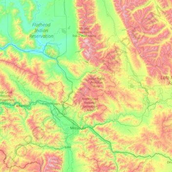
Name: Missoula County topographic map, elevation, terrain.
Location: Missoula County, Montana, United States of America (46.63158 -114.79755 47.60108 -113.30366)
Average elevation: 1,474 m
Minimum elevation: 755 m
Maximum elevation: 2,970 m
Other topographic maps
Click on a map to view its topography, its elevation and its terrain.
Fergus County
United States of America > Montana
Fergus County, Montana, United States of America
Average elevation: 1,139 m
Big Horn County
United States of America > Montana
Big Horn County, Montana, United States of America
Average elevation: 1,220 m