
Make a donation
Gear up for your next adventure:
As an Amazon Associate, this site earns from qualifying purchases at no extra cost to you.
Kitsman topographic map
Click on the map to display elevation.
Make a donation
Gear up for your next adventure:
As an Amazon Associate, this site earns from qualifying purchases at no extra cost to you.
About this map
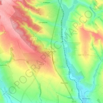
Name: Kitsman topographic map, elevation, terrain.
Average elevation: 245 m
Minimum elevation: 183 m
Maximum elevation: 321 m
Make a donation
Gear up for your next adventure:
As an Amazon Associate, this site earns from qualifying purchases at no extra cost to you.
Other topographic maps
Click on a map to view its topography, its elevation and its terrain.
Chernivtsi
The city is located in a temperate climate zone. The climate is continental with mild winters and warm summers. The average annual temperature is +8,6 °C (47 °F), the lowest in January (-2,9 °C; 27 °F), the highest – in July (+19,8 °C; 68 °F). Winter weather usually comes on 28 November and ends 9…
Average elevation: 226 m
Make a donation
Gear up for your next adventure:
As an Amazon Associate, this site earns from qualifying purchases at no extra cost to you.