
Bailhongal topographic map
Interactive map
Click on the map to display elevation.
About this map
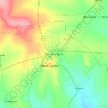
Name: Bailhongal topographic map, elevation, terrain.
Location: Bailhongal, Bailahongala taluku, Karnataka, 591102, India (15.77642 74.81687 15.85642 74.89687)
Average elevation: 685 m
Minimum elevation: 636 m
Maximum elevation: 754 m
Other topographic maps
Click on a map to view its topography, its elevation and its terrain.
Mohare
India > Karnataka > Bailahongala taluku
Mohare, Bailahongala taluku, Belgaum district, Karnataka, 591121, India
Average elevation: 818 m
Kittur
India > Karnataka > Bailahongala taluku > Kittur
Kittur, Bailahongala taluku, Belgaum district, Karnataka, 591115, India
Average elevation: 724 m